
Rose falls / Rose Lake overlook
August 2021
boundary waters canoe area
Conditions: August in the Boundary Waters can be a gamble — either dry heat and still air, or passing cloud systems that break up the light just enough to make the land feel alive. On this day, scattered clouds moved slowly across the sky, leaving wide openings for deep blue and late-summer sun to spill across the lakes and ridgelines.
Despite the time of year, Rose Falls was still flowing strong, cascading through the rock cut between Duncan Lake and Rose Lake along what is known as the Stairway Portage — a well-used portage made famous for its long wooden staircases that descend toward the border lake below. 
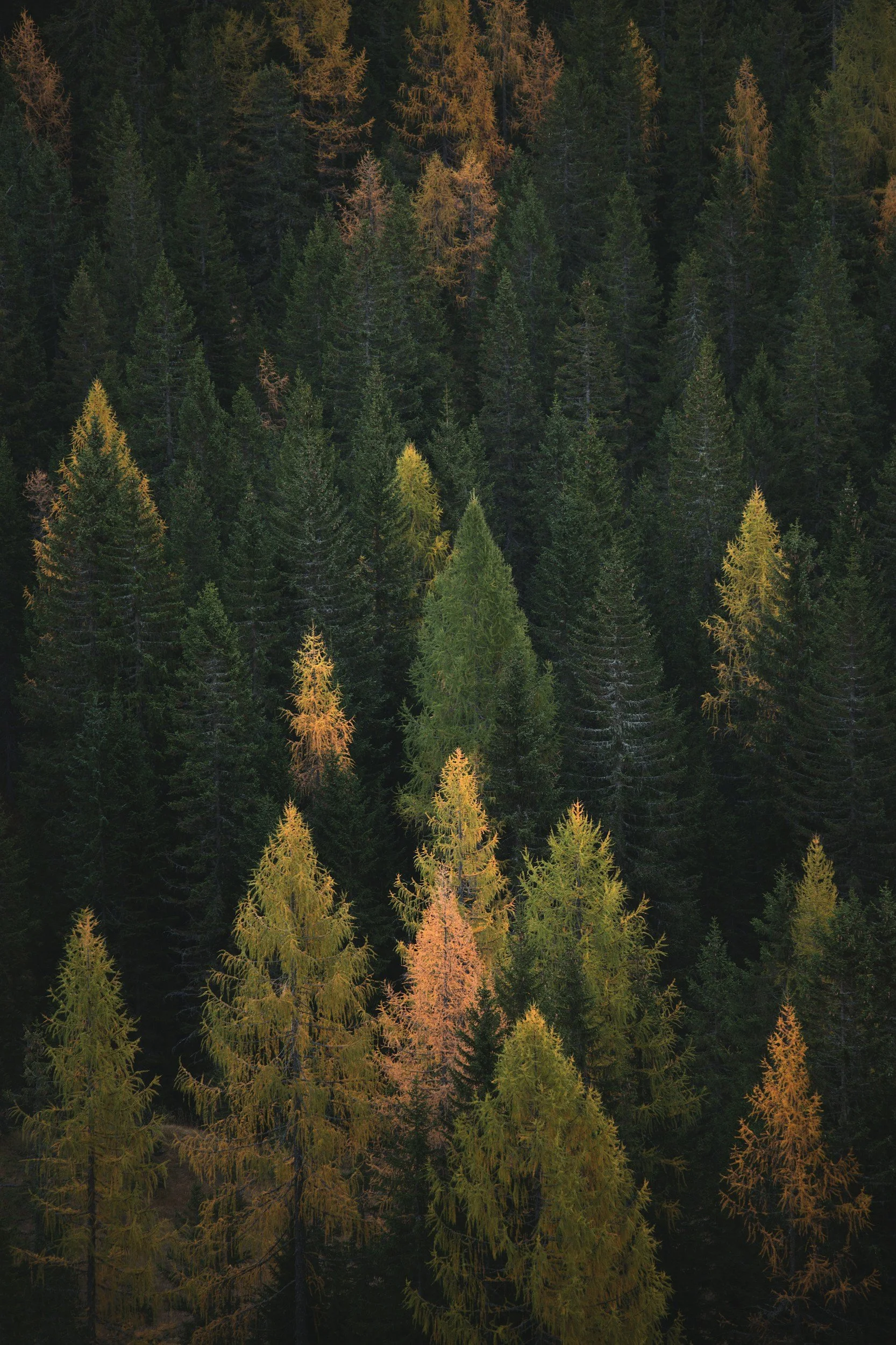
Water levels were healthy for late summer, and the surrounding forest — white pine, cedar, and boreal understory — still held the dense green of midseason growth. 
Purpose of Journey: To document one of the most iconic interior destinations along the international border route of the Boundary Waters — where moving water, exposed cliffs, and ancient geology meet in a rare convergence of access and remoteness.
This journey followed a classic interior canoe route beginning from Hungary Jack Road access via West Bearskin Lake, paddling through Duncan Lake before reaching Rose Lake. From the Stairway Portage, access to both Rose Falls and the Rose Lake Overlook along the Border Route Trail allowed for an exploration of this landscape from both water and elevation — capturing not only the falls themselves but the dramatic ridgelines formed by the Rove Formation that rise nearly 300 feet above the lake’s surface. 
Field Notes: Rose Lake sits directly along the international boundary between Minnesota and Ontario — a 1,300+ acre border lake carved into long east-west ridges of ancient Animikie slate and diabase that now define the cliff systems seen from above. 
After navigating from West Bearskin through Duncan Lake, the trail from the Stairway Portage connects directly to the Border Route Trail, a 65-mile volunteer-built wilderness footpath that traces the edge of the U.S.–Canada border through some of the most rugged topography in the BWCA. 
From this junction, the Rose Lake Overlook rises sharply above the southern ridge — offering exposed rock platforms with uninterrupted views across the lake toward Canada. These cliffs, sometimes referred to as the Rose Cliffs, are one of the few elevated vantage points in the dense boreal canopy where the terrain drops away dramatically enough to reveal the true scale of the border lakes below. 
Standing above Rose after approaching it by paddle feels like stepping briefly outside the forest’s grip — the same lake that hides itself from within suddenly laid open in slate, light, and wind.
Long before the Border Route Trail was carved into these ridges by volunteers in the 1970s, this chain of lakes formed part of an ancient travel corridor used by Anishinaabe voyageurs and earlier Indigenous travelers moving between the inland waters and Lake Superior. The natural stair-stepping terrain between Duncan and Rose — now formalized as the Stairway Portage — mirrors the same elevation breaks that once guided seasonal movement, trade routes, and canoe passage across what is now the international border.
Even today, the falls continue to flow along pathways first followed by water — and then by those who learned to follow it.

Johnson Falls - Pine Lake
august 2021
superior national forest / bwca
Conditions: August of 2021 fell within a major statewide drought event across Minnesota, as persistent moisture deficits and above-normal summer temperatures led to reduced streamflow across much of the state — including northeastern Minnesota and the Superior National Forest. 
Climate data from the Minnesota State Climatology Office shows that the drought intensified through the summer months, with August remaining generally warm and precipitation levels across northeastern Minnesota falling below seasonal norms in many areas. 
Despite these reduced hydrologic conditions, Johnson Falls was still flowing steadily — though likely at a diminished late-season rate compared to peak spring runoff. The exposed bedrock and narrower chute structure of the Johnson Falls drainage often allows it to maintain visible flow later into dry seasons when broader wetlands and surface streams have already receded.
Skies on this particular day were clear with late-summer sun filtering through the canopy along Pine Lake and the river corridor leading inland toward the falls.
Purpose of Journey: To document one of the most accessible interior waterfalls within the Boundary Waters Canoe Area Wilderness — located along the drainage between Pine Lake and the higher interior ridge systems of the Border Route corridor.
This route followed a classic eastern Gunflint paddle sequence beginning from Clearwater Lake through Caribou Lake, Little Caribou Lake, and into Pine Lake before continuing by foot approximately half a mile upstream along the rocky riverbed to reach Johnson Falls.
The objective was to capture both tiers of the falls during late-season flow conditions — a time when reduced water volume reveals the underlying geology of the cascade. 
Field Notes: Johnson Falls consists of two separate drop systems located along the same drainage channel — with the lower falls appearing first upon approach from the Pine Lake access trail.
Many visitors stop here, assuming they’ve reached the full extent of the site.
However, the upper falls lie further upstream, accessible by briefly backtracking along the trail before continuing inland along the main footpath. This second cascade drops through a narrower rock corridor and often presents a more vertically defined chute — particularly scenic when viewed under lower summer flow.
The drainage feeding Johnson Falls flows southward toward Pine Lake — itself part of the larger international watershed that ultimately drains north toward the Rainy River basin along the U.S.–Canada border.
In dry-season years like 2021, reduced runoff can expose portions of the riverbed leading to the falls, allowing access by walking sections of exposed rock and shallow channel.
Pine Lake lies along a historic east-west travel corridor used for generations by Anishinaabe travelers moving between inland lake systems and the greater border watershed.
Small interior falls such as Johnson would not have served as destinations in themselves — but rather as markers along seasonal canoe routes, signaling elevation change, safe portage access, or narrowing terrain between lake basins.
Today, the same drainage still moves quietly toward Pine — following paths first read not as scenery, but as instruction.

TORNADO - CLEARWATER LAKE
October 2021
BOUNDARY WATERS CANOE AREA / SUPERIIOR NATIONAL FOREST
(NWS-confirmed tornado in the Superior National Forest / Gunflint Trail region)
Conditions: On the evening of October 10, 2021, a powerful storm system moved across northeastern Minnesota, bringing intense lightning, heavy rainfall, hail, and strong convective wind gusts to the Gunflint Trail corridor and surrounding Superior National Forest.
According to the National Weather Service in Duluth, a brief but impactful EF-0 tornado touched down in a remote portion of the Boundary Waters Canoe Area Wilderness near Clearwater Lake. The tornado carved a narrow but concentrated path of damage through mature boreal forest, snapping and uprooting hundreds of trees along a northeast trajectory consistent with tornadic rotation rather than straight-line wind or microburst activity.
The damage path extended across wilderness terrain between Clearwater Lake and Mountain Lake, impacting sections of the Border Route Trail and surrounding backcountry areas. Initial reports suggested a possible microburst due to the localized nature of the damage. However, following an aerial damage survey conducted by the U.S. Forest Service in coordination with the National Weather Service, the event was officially classified as a tornado based on observed tree-fall patterns and convergent wind signatures typical of tornadic circulation.
Purpose of Journey: Three days after the storm system passed through the area, I made a routine trip down toward Clearwater Lake to inspect shoreline conditions before seasonal boat removal. With no indication of large-scale disturbance visible from the lodge or surrounding access points, the intent was simply to assess windfall or storm debris along commonly traveled routes prior to winter.
What began as a routine end-of-season check quickly shifted into an informal field survey after encountering extensive and unusual blowdown along the trail system—damage severe enough to fully obscure sections of the established route and render passage difficult or impossible in places.
Field Notes:The VIDEO accompanying this log documents my initial discovery of the damage path on October 18, 2021 — three days after the storm event.
Large swaths of mature spruce and pine had been snapped or uprooted in a tight, directional pattern inconsistent with the broader wind events typical of fall storms along the Gunflint Trail. Entire sections of trail were buried beneath crisscrossed trunks and suspended root systems, with tree fall appearing to converge inward along a defined corridor.
After reporting these findings to the U.S. Forest Service, the event was initially believed to be the result of a localized microburst. However, a subsequent aerial reconnaissance survey revealed rotational damage patterns — including opposing fall directions and convergent lay — ultimately leading to official classification of the event as an EF-0 tornado by the National Weather Service.
At the time of reporting, this discovery represented the first known documentation of the tornado’s impact within this section of the BWCAW.
Long before the Border Route Trail crossed these ridgelines, the lakes and uplands surrounding Clearwater formed part of the seasonal travel and trade networks of the Anishinaabe people. Sudden forest disturbance — whether from fire or storm — was not seen solely as destruction, but as renewal. Blowdown created openings for berry growth, moose browse, and early successional plant life that would sustain both wildlife and human movement through the forest.
Even today, events like the Clearwater tornado quietly reshape the living memory of the land — altering trails, shifting habitat, and reminding us that wilderness is not static, but always in motion beneath wind, water, and time.
BWCA EP 82 - CARIBOU ROCK TRAIL
SEPTEMBER 2021
BOUNDARY WATERS CANOE AREA / SUPERIIOR NATIONAL FOREST
Entered via Caribou Rock Trailhead (EP 82) off Hungry Jack Road.
Hiked northbound along the Caribou Rock Trail past:
• West Bearskin Lake Overlook (~0.75 mi)
• Moss Lake Overlook (~1.5–2 mi)
• Duncan Lake ridgeline views
• Stairway Portage / Rose Falls junction
Continued to intersection with the Border Route Trail, using the spur connection near Rose Lake before returning via the same route.
The Caribou Rock Trail serves as a primary access spur to the 65-mile Border Route Trail, which follows the international border between Minnesota and Ontario through some of the most rugged terrain in the Boundary Waters Canoe Area Wilderness.
Conditions: Early autumn conditions typical of the Gunflint uplands.
• Overcast skies during the early portion of the hike
• Cool late-September air with minimal wind
• Ground cover still largely green — pre-peak fall color
• Cloud cover gradually broke by mid-afternoon
• Blue skies and direct sun illuminating ridge-top overlooks toward the end of the hike
The clearing conditions created stark lighting across Moss Lake and West Bearskin, offering high-contrast visibility into valleys normally muted under canopy.
Purpose of Journey: To travel the historic Caribou Rock spur trail from its BWCA entry to its intersection with the Border Route Trail, documenting terrain, ridge-line overlooks, and lake-basin views during the transitional period between late summer and fall.
This section of trail is often cited as one of the most rugged mile-for-mile hiking routes in the BWCA, climbing repeatedly from lowland bog and creek crossings up to exposed ridges overlooking Moss Lake, Duncan Lake, and West Bearskin Lake. 
With peak foliage still days away, the goal was to capture the quiet threshold between seasons — before the boreal forest shifts into its autumn burn.
Field Notes: The Caribou Rock Trail wastes no time gaining elevation. Within the first three-quarters of a mile, the forest thins and the ground begins to fall away beneath you — revealing the long blue reach of West Bearskin Lake through a clearing in the spruce.
Another mile in, Moss Lake appears from above — held in a bowl of ridges carved by retreating glacial ice. From this vantage, it becomes clear why this trail was routed along the heights. The terrain here moves in waves — ridge to valley, bluff to creek — forcing you to climb with your hands as often as your feet in places. 
Late in the day, the ceiling lifted.
Cloud gave way to fractured blue — sunlight pushing through the jack pine canopy and igniting the water below in brief flashes of silver. The overlooks that had felt enclosed all morning opened outward toward Canada, toward the Voyageur highway of lakes that once carried trade routes and birchbark hulls.
By the time the trail met the Border Route — itself first laid out by volunteers in the early 1970s along the international divide — the forest had shifted tone completely. What began as shadowed and subdued ended in light.
Long before it was formalized into hiking trail or entry point, this corridor formed part of a vast travel network used by the Anishinaabe and earlier Indigenous peoples moving between inland hunting grounds and the border lakes. The high ridgelines above Moss and Bearskin would have provided strategic vantage across water routes that now mirror the historic canoe highway linking Lake Superior to the interior. These overlooks are not only scenic—they are ancient ways of seeing.