SEASONAL RECORD
2021 - 2025
The Seasonal Record documents the shifting environmental patterns observed throughout the year along the Gunflint Trail and surrounding Boundary Waters region.
From freeze-up and spring breakup to mid-summer bloom and the return of auroral activity in late August, these entries reflect the cyclical changes that shape both travel conditions and creative work across the Northwoods. Returning to the same lakes, trails, and overlooks across seasons allows for a more grounded understanding of how light, weather, and ecological transitions influence the experience of place over time.
Each entry below captures a moment within that cycle — forming part of an ongoing observational archive rooted in lived experience on the land.

DARK SKY SANCTUARY STUDY
january 2024-25
BWCA / SUPERIOR NATIONAL FOREST
Conditions: Variable night-sky conditions observed across multiple seasons throughout 2024, including clear summer Milky Way visibility, intermittent autumn auroral activity, and winter moonrise under sub-zero temperatures. Periods of atmospheric haze and shifting cloud cover were present at times, though extended intervals of stable, low-light conditions allowed for consistent astrophotography and timelapse documentation across the Boundary Waters and adjacent forest regions.
Purpose of Study: To conduct a year-long visual study of nocturnal sky conditions across the Boundary Waters Canoe Area Wilderness and Superior National Forest — documenting seasonal celestial patterns including Milky Way position, lunar cycles, and auroral activity through repeated timelapse observation over the course of 2024.
Field Notes: This compilation represents a year-long documentation effort focused on the night sky above the Boundary Waters region — drawn from multiple overnight sessions across lake basins, forest clearings, and shoreline overlooks throughout 2024. The resulting sequences capture the Milky Way’s seasonal rotation, intermittent northern lights activity, and the shifting presence of moonlight across open wilderness terrain.
Filming took place within one of the few designated dark sky sanctuaries in the world — a status granted in recognition of the region’s exceptionally low levels of artificial light pollution by DarkSky International. These conditions allow for extended visibility of faint celestial detail rarely observable in more developed areas.
Returning to the same locations across changing seasons revealed subtle variations in atmospheric clarity, sky brightness, and auroral frequency — reinforcing the value of repeated night-based observation as part of an ongoing environmental and creative practice.
For the Anishinaabe, the night sky has long served as more than just a source of wonder—it was a living map of story and guidance woven into the rhythms of the natural world. Constellations such as Mooz (the Moose) and Biboonkeonini (the Wintermaker) were understood not only as figures in the stars, but as seasonal markers—signaling changes in weather, migration, and time for travel across frozen lakes or open water. The Big Dipper, known as Ojiig or the Fisher, carries with it teachings about survival and sacrifice, its position in the sky shifting with the seasons just as life on the land must adapt to the turning of the year. In this way, the stars became part of a broader relationship between land, water, and sky—guiding movement across the wilderness long before compasses or maps, and connecting those who traveled by canoe to the same celestial patterns that still unfold above the Boundary Waters today.
frozen WILDERNESS
january 2024
SUPERIOR NATIONAL FOREST
Conditions: Recording took place throughout January 2024 during a period of fluctuating winter temperatures across the Boundary Waters and Superior National Forest. Early in the month, cold weather helped stabilize lake ice throughout the region, with reported thickness in parts of the BWCA ranging from approximately 5 inches up to nearly a foot depending on location and exposure. However, the winter of 2023–2024 brought relatively mild conditions overall, with minimal snow cover across northern Minnesota allowing ice to form unevenly across open water. 
A brief cold snap during mid-January contributed to increased ice formation across inland lakes, while larger bodies of water such as Lake Superior reached only about 15% seasonal ice cover—well below historical averages—before warmer temperatures in the following weeks reduced coverage again.  These rapid temperature fluctuations created dynamic freeze–thaw cycles across interior lakes such as Clearwater, leading to the expansion and contraction of newly formed ice sheets and producing the pressure fractures and acoustic activity documented during this recording period.
Purpose of Study: This study was undertaken to document the natural acoustic environment of early winter ice formation on Clearwater Lake within the Superior National Forest. By recording the sounds produced during the transitional freeze-up period, the goal was to capture the physical processes that occur as open water becomes structurally stable ice—revealing the subtle interactions between temperature, pressure, and lake dynamics. These recordings serve both as environmental documentation and as a sensory exploration of seasonal change in the Boundary Waters landscape, preserving a rarely observed dimension of winter’s arrival through sound rather than sight.
Field Notes: Over the course of several days on Clearwater Lake, I recorded the subtle but often startling sounds of new ice forming across the surface. In northern Minnesota, lakes throughout the Boundary Waters and Superior National Forest typically begin freezing first along sheltered bays and shallow shoreline margins before expanding outward toward deeper water, eventually forming a continuous ice sheet that behaves much like a suspended membrane stretched across the lake. As early winter temperatures fluctuate—sometimes by 20 to 40 degrees within a single day—the ice responds by expanding and contracting under immense internal pressure. These stresses are released through minute fractures and shifting plates across the surface, sending vibrations outward through both ice and water. The result is an eerie chorus of creaks, groans, sharp cracks, and distant resonant booms—sometimes referred to as “singing ice.” These sounds are not signs of weakness, but rather the lake adjusting to rapid thermal change as it settles into the frozen season.
For the Anishinaabe, the formation of ice marked more than the arrival of winter—it signaled a shift in seasonal movement across the land. Frozen lakes became reliable travel routes, allowing for direct passage between hunting grounds, gathering areas, and winter camps that would otherwise require long detours through dense forest. The changing sounds of the ice—its tightening, shifting, and settling—were understood as part of the living character of the lake itself, offering cues about thickness, stability, and safe passage. In this way, the frozen surface was not simply an obstacle, but a seasonal transformation of the landscape—one that opened new pathways across waters long traveled by canoe in warmer months, guided by knowledge passed down through generations living in rhythm with the land and its winter silence.
PIKE FISHING - RUDY LAKE
AUGUST 2023
BWCA / SUPERIOR NATIONAL FOREST
Route: Golden Eagle Lodge → Flour Lake (motorboat access) → Portage to Rudy Lake Multi-day trips with paddle-only travel on Rudy Lake using an aluminum boat staged on shore by Golden Eagle Lodge
Conditions: Weather: Mixed conditions throughout trip—alternating blue skies and overcast days Precipitation: Minimal to none Travel Notes: Motorized access permitted on Flour Lake; paddle-only travel required on Rudy Lake
Purpose of Study: This multi-day trip into Rudy Lake was centered around fishing and time spent traveling with my friend Nate—an experienced angler with a strong understanding of northern Minnesota fisheries. With Rudy’s non-motorized status and limited access requiring both a lake crossing and portage, the goal was to spend several days targeting northern pike in a quieter, low-pressure environment typical of smaller interior lakes in the Superior National Forest.
The use of a staged aluminum paddle boat allowed for efficient access to deeper structure while maintaining compliance with the lake’s motor restrictions.
Field Notes: Access to Rudy Lake required an initial motorized crossing of Flour Lake followed by a short portage into the interior basin, where a rental aluminum paddle boat provided by Golden Eagle Lodge was staged along the shoreline. Rudy is designated as a non-motorized lake, allowing only paddle-powered watercraft once inside—helping to limit fishing pressure and maintain quieter conditions throughout the season.
Northern pike (Esox lucius) populations throughout the Superior National Forest are often supported by cool, oxygen-rich waters and abundant vegetative cover—conditions that tend to produce aggressive feeding behavior, particularly during mid to late summer when surface temperatures begin to stabilize. While no exceptionally large individuals were landed during this trip, the population on Rudy proved both active and plentiful, resulting in consistent action over several days of fishing.
Rudy’s relative isolation—combined with its motor restrictions—likely contributes to reduced angling pressure compared to more accessible lakes in the region. Over the course of the trip, changing sky conditions from clear to overcast appeared to influence activity levels, with pike remaining consistently aggressive along shallow structure and weed edges.
Indigenous ContextRudy Lake lies within the traditional homeland of the Anishinaabe, whose relationship with these inland waters extended far beyond recreation. Fish species such as northern pike have long served as both seasonal food sources and cultural touchstones—harvested sustainably across interconnected lake systems throughout what is now the Superior National Forest.
BROOK TROUT fishing
june 2023
boundary waters canoe area
Conditions: Weather: Stable early-summer conditions. Travel Notes: Steep and heavily overgrown trail access BRT; physically demanding route
Purpose of Study: This early-season trip into Gogebic Lake—shared with Dan and Chris (owner of Clearwater Historic Lodge)—was centered around assessing the brook trout fishery in one of the more remote interior lakes along the eastern Boundary Waters. With Dan’s experience as an angler and Chris’s familiarity with the surrounding route system, the goal was not only to fish, but to observe overall population health, catch rates, and fish condition within a lake that receives relatively low angling pressure due to its difficult access.
Many smaller inland lakes within the Superior National Forest are either supported through periodic Minnesota DNR stocking efforts or managed as naturally reproducing coldwater fisheries, depending on available spawning habitat and water temperature stability. Remote lakes such as Gogebic—characterized by cold, oxygen-rich waters—are often capable of sustaining brook trout (Salvelinus fontinalis) populations where natural reproduction is viable. This trip provided an opportunity to evaluate fish abundance and behavior firsthand in a minimally pressured environment, offering insight into the health and sustainability of the lake’s interior fishery.
Field Notes: Travel began across Clearwater Lake before portaging toward West Pike and eventually connecting to the Border Route Trail via the Asper Trail. This inland section proved to be one of the more physically demanding approaches in the area—steep, narrow, and significantly overgrown in places—requiring sustained effort to reach Gogebic Lake.
Gogebic sits in a glacially carved depression along the ridge system that separates inland waters draining toward the Pigeon River watershed. Its bowl-like topography and steep surrounding terrain create a uniquely enclosed environment. When positioned near the center of the lake, even slight contact between paddle and canoe hull can produce an amplified resonance across the still water—likely influenced by the surrounding bedrock formations and basin shape.
The lake supports a population of brook trout (Salvelinus fontinalis), which tend to thrive in cold, well-oxygenated inland lakes such as this—particularly those with limited access and minimal angling pressure. Fishing conditions throughout the trip were exceptionally productive, with limits reached relatively quickly despite the effort required to access the lake.
One of the two designated campsites on Gogebic features hand-built furniture constructed from slate rock gathered from the surrounding shoreline—evidence of long-term backcountry craftsmanship by unknown visitors in seasons past.
Though well worth the journey, access to this lake demands a level of effort that naturally limits visitation—helping to preserve both its fisheries and its sense of isolation.
Gogebic Lake lies within the traditional homeland of the Anishinaabe, whose seasonal movement across inland lake systems often followed elevated ridgelines and watershed boundaries such as those found along this route. Coldwater species like brook trout have long been harvested from similar highland lakes throughout the region as part of broader subsistence patterns connecting interior waters to the Lake Superior basin.
aurora observation event
MARCH 2023
BWCA / SUPERIOR NATIONAL FOREST
Conditions: On the evening of March 23, 2023, geomagnetic activity over the northern United States increased due to elevated solar wind speeds interacting with Earth’s magnetosphere—likely associated with a coronal hole high-speed stream impacting the planet’s magnetic field.
These solar wind interactions resulted in:
• Increased geomagnetic disturbance levels (Kp Index ~4–5)
• Southward orientation of the interplanetary magnetic field (Bz)
• Enhanced particle precipitation into the upper atmosphere
• Expanded auroral oval visibility across northern Minnesota
Surface weather conditions over the Boundary Waters Canoe Area Wilderness were seasonally cold with intermittent high cloud presence earlier in the evening. Partial clearing allowed for improved sky visibility during peak geomagnetic interaction.
Residual atmospheric ice crystals present in the cold March air column created subtle diffusion of auroral light through thin cloud layers—occasionally producing a soft halo effect and broadening the perceived width of auroral arcs as viewed from the frozen surface of Clearwater Lake.
Purpose of Study: This observation session was undertaken to document a geomagnetic aurora event occurring over the Boundary Waters region on March 23, 2023.
Primary objectives included:
• Recording auroral structure and motion during moderate geomagnetic activity
• Observing atmospheric light interaction under late-winter conditions
• Capturing long-exposure imagery and time-lapse footage of auroral movement
• Documenting the visual relationship between frozen lake surfaces and skyglow
The session also served to assess visibility conditions for auroral photography from lake-level vantage points within the Superior National Forest.
Field Notes: The aurora began as a low band along the northern horizon—faint enough at first to be mistaken for distant cloud illuminated by moonlight. But over the course of the evening, the band intensified—gaining structure, rising into slow-moving arcs that stretched above the tree line along the far shoreline of Clearwater Lake.
As is often the case in late winter, thin upper-level cloud passed intermittently across the sky. Rather than obscuring the light, these layers softened it—spreading the green emissions outward into broader curtains that seemed to glow from within the atmosphere itself.
Standing on the frozen lake surface, the distinction between sky and land became less defined. Movement above reflected faintly across wind-scoured ice while darker forest edges held still beneath it. The aurora did not arrive all at once, but in pulses—brightening and fading in waves tied to unseen solar interactions occurring far beyond the Earth.
For generations, the Anishinaabe have described the northern lights as a presence rather than a phenomenon—sometimes understood as the spirits of ancestors moving across the sky or the flicker of fires in the spirit world. In winter especially, when the land grows quiet and the lakes freeze into stillness, the appearance of this light has long carried meaning beyond weather or science. On nights like this, it is easy to understand how the aurora came to be seen not just as light in the sky—but as movement between worlds.
SUNSET STUDY - HONEYMOON BLUFF
DECEMBER 2022
SUPERIOR NATIONAL FOREST
Conditions: During December of 2022, the Gunflint Trail region experienced prolonged periods of Arctic air driven south from central Canada—resulting in consistently cold surface temperatures, steady wind exposure across inland lake basins, and intermittent mid-level cloud cover throughout the Superior National Forest.
Cold continental air masses interacting with occasional lake-influenced moisture from nearby inland waters created:
• Persistent Partly Cloudy Stratocumulus formations
• Wind-shaped snowpack across exposed ridgelines
• Elevated atmospheric ice crystal content near sunset hours
• Low-angle solar scattering through suspended frost and snow particulates
Under these winter conditions, sunsets often displayed extended twilight periods due to the sun’s shallow path along the southern horizon. Suspended ice crystals and wind-borne snow enhanced red-orange wavelength scattering—producing prolonged alpenglow effects across cloud decks and treetops commonly observed from elevated overlooks such as Honeymoon Bluff.
Field conditions during documentation were consistently cold, windy, and partly cloudy, with winds at elevation often stronger than those recorded at lake level due to unobstructed exposure along the bluff face above Hungry Jack Lake.
Purpose of Study: This study documents a series of winter sunset conditions observed from Honeymoon Bluff during December of 2022.
The goal was to visually record:
• Seasonal solar angle and low-light atmospheric behavior
• Cloud interaction with winter sunset light
• Snow-covered boreal landscape response to twilight conditions
• The influence of elevation and wind exposure on sunset visibility
Honeymoon Bluff—accessed via a short but steep trail of roughly 0.4 miles—offers a rare west-facing overlook of Hungry Jack Lake and surrounding boreal forest, making it one of the more accessible sunset observation points along the Gunflint Trail.
Field Notes: There are few places along the Gunflint Trail where the effort-to-reward ratio is as immediate as Honeymoon Bluff. A short climb through spruce and pine opens suddenly into sky—into distance—into winter light spilling across Hungry Jack Lake and the Boundary Waters beyond.
In December, the formations change. The lakes freeze. The trees carry weight. The clouds move slower, pulled thin by wind and shaped by cold rather than convection. Sunset arrives not as a sudden burst of color, but as a long withdrawal—light catching on wind-drifted snow, cloud edges burning briefly above the darkening forest before settling into violet and ash.
From above the frozen basin, it becomes clear why this overlook has become such a popular sunset destination in any season. The western exposure across inland lakes allows an uninterrupted view of the sun’s final arc—often stretching twilight well beyond what is visible at lake level.
For generations, elevated rock outcrops such as these served as lookout points across travel corridors used by the Anishinaabe and later voyageurs moving between lake systems. Even now, standing above Hungry Jack in the stillness of winter, it is easy to imagine the sky not as backdrop—but as signal. A shifting boundary between day and night, land and spirit, marked in color across the horizon.

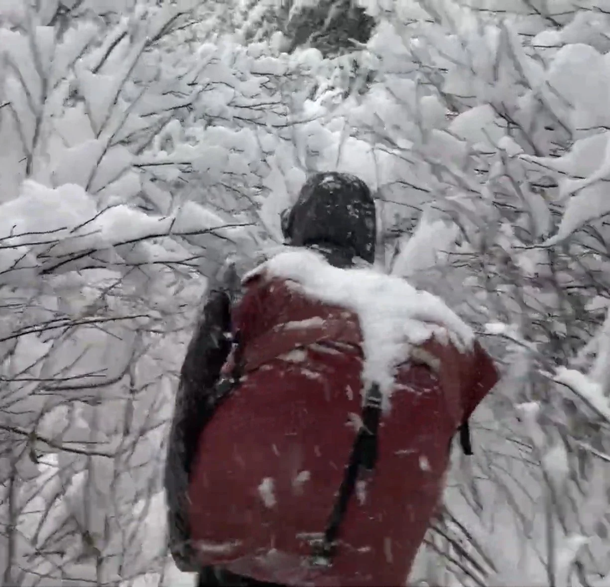
WINTER CAMP - SNOWFALL
NOVEMBER 2022
boundary waters canoe area - CARIBOU ROCK TRAIL / BRT/ ROSE FALLS
Conditions: n mid-November of 2022, a powerful early-season winter storm system moved across the Arrowhead region of Northern Minnesota—impacting the Boundary Waters Canoe Area Wilderness and Superior National Forest with some of the first significant snowfall totals of the season.
Between approximately November 13–18, the Gunflint Trail corridor received widespread accumulation from a moisture-rich low-pressure system tracking northeast across the Upper Midwest. Recorded snowfall totals in the inland trail region included:
• 20 inches – West Bearskin Lake
• 16.5 inches – Poplar Lake
• 10–12 inches – Hovland / Lutsen corridor
• Localized totals approaching 25–30 inches in elevated inland areas west of Hovland
Much of this snow fell over a period of 48–72 hours and remained unconsolidated due to persistently cold post-storm temperatures—resulting in deep, dry powder across interior trail systems such as the Caribou Rock and Border Route Trails.
Moderate northeast winds following the system contributed to drifting along exposed ridgelines above Rose Lake, while sheltered forest sections held softer accumulation ranging between 10–15 inches at the time of travel. This marked one of the first major snow-loading events of the 2022–2023 winter season in the Superior National Forest—effectively transitioning interior trail conditions from late-fall to full winter travel within days.
Purpose of Study: Upon hearing that a substantial early-season snowfall was approaching the region, Dan and I made the decision to undertake an overnight winter hike into the Border Route corridor to experience the storm conditions directly within the wilderness.
The objective of this journey was to travel through active and recently accumulated snowfall in order to observe how rapidly changing weather conditions reshape interior trail systems, frozen hydrological features, and boreal terrain during the onset of winter.
Field Notes: We entered via the Caribou Rock Trail as snowfall continued to accumulate across the forest floor—each step breaking through what would eventually measure close to a foot of fresh powder in sheltered areas along the route.
After reaching the Border Route Trail, we made our way toward Rose Falls. Under heavy snowfall, the falls had begun their seasonal transition—water pushing slowly beneath growing shelves of ice while fresh accumulation gathered along rock faces and suspended branches overhead. The entire drainage had taken on a muted stillness as snow absorbed the sound of moving water beneath it.
On our return from the falls, we noticed a separate set of tracks running parallel to our own—fresh wolf prints laid down sometime during the storm, trailing our route through the newly fallen snow.
Continuing east along the Border Route Trail, we reached one of the designated shuttle sites where we eventually made camp in what appeared to be roughly 12 inches of fresh accumulation. Hammocks were set beneath snow-laden spruce while temperatures dropped steadily into the night. We bundled into −30°F sleeping bags as wind moved through the upper canopy above us.
In the excitement of the hike, I had failed to adequately shed layers during travel—resulting in sweat-dampened clothing by the time we reached camp. While attempting to set up my hammock, I noticed a progressive loss of dexterity in my hands due to rapid heat loss. Eventually, I required assistance from Dan just to ignite the stove—my hands no longer responsive enough to operate the lighter on my own.
It remains one of the more physically demanding winter camping experiences I’ve undertaken—where early-season snowpack and enthusiasm moved faster than caution.
For generations, the high ridgelines and portage routes connecting lakes such as Rose and Watap have served as seasonal travel corridors for the Anishinaabe. In winter especially, fresh snowfall would have altered movement across these routes in much the same way—transforming familiar pathways into something quieter, deeper, and far less certain beneath the first true storms of the season.
winter skies study
winter 2022-23
BWCA / SUPERIOR NATIONAL FOREST
Conditions: Between December of 2022 and March of 2023, the Boundary Waters Canoe Area Wilderness experienced one of the more thermally dynamic winters in recent memory. Persistent Arctic air masses moving south across central Canada frequently interacted with intermittent warm fronts rising out of the Plains—creating ideal atmospheric instability for cloud formation over the Superior National Forest.
This push–pull between cold continental air and moisture-bearing southern systems produced:
• Frequent Altostratus and Stratocumulus decks
• Ice-crystal rich Cirrostratus veils
• Occasional diamond dust precipitation under extreme cold conditions
• Rapidly forming lake-effect cloud bands along the Gunflint corridor
When temperatures dropped below −15°F (−26°C), suspended ice crystals in the lower atmosphere increased dramatically—enhancing lunar halos, light pillars, and subtle auroral diffusion across thin cloud layers. These conditions often resulted in slow-moving, high-contrast winter cloud structures that became visible even under low starlight or moonlight during long-exposure imaging.
Stable surface inversions over Clearwater Lake’s frozen basin also allowed cloud formations to persist longer than typical—creating time-lapse opportunities rarely seen during more turbulent shoulder seasons.
Purpose of Study: This collection of winter sky time-lapse footage and still imagery was gathered over several nights throughout the winter of 2022–2023 to document the seasonal atmospheric conditions of the boreal sky above Clearwater Lake.
The goal of this study was to observe and visually record:
• Winter cloud behavior under extreme cold conditions
• The interaction between auroral activity and thin cloud cover
• Night sky visibility through layered ice-crystal formations
• The changing relationship between moonlight, starlight, and frozen atmospheric moisture
By capturing extended sequences over multiple months, this project aims to explore how winter weather patterns influence the visibility and motion of celestial phenomena in sub-arctic environments such as the Boundary Waters Canoe Area Wilderness.
Field Notes: Winter skies above Clearwater Lake behave differently than in any other season. Clouds do not build with thunder or wind, but with silence—growing slowly out of suspended frost and distant pressure systems until they stretch across the stars like breath across glass.
On certain nights, high-altitude cirrus would move invisibly to the naked eye, revealed only through long exposure as pale bands slipping across Orion or the rising arc of the Milky Way. At other times, dense low-level ice fog formed directly above the frozen lake surface—turning starlight into halos and bending moonlight into luminous columns that reached upward into the dark.
Auroral activity during this winter often passed behind thin cloud layers, giving the impression that the light was emerging from within the atmosphere itself rather than beyond it. The result was less a curtain in the sky and more a diffuse glow—slow and tidal—interacting constantly with cloud forms shaped by cold alone.
For generations, the Anishinaabe have understood the winter sky not as empty space but as a place of movement and spirit. Some teachings describe the northern lights as the presence of ancestors or a reflection of the spirit world—visible only when conditions between realms grow thin. On nights when the clouds part just enough to let the stars through, it becomes easier to understand how sky and land were never meant to be separate, but part of the same living system above the lakes.
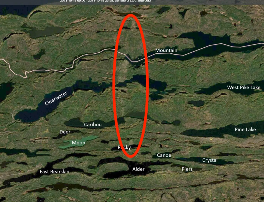
EAST PALISADE - CLEARWATER LAKE
AUGUST 2022
boundary waters canoe area
Purpose of Study: To explore an untrailed section of the Clearwater Palisades by ascending the eastern ridgeline without the aid of a maintained hiking route—seeking a more remote vantage point above the lake and attempting to establish a direct visual relationship with the Clearwater basin from a perspective rarely experienced by paddlers or hikers traveling the traditional west-side trail.
Conditions: Clearwater Lake sits beneath a series of sheer cliff formations known locally as the Palisades—towering escarpments that rise more than 300 to nearly 400 feet above the lake’s surface. 
These cliffs are accessible primarily by watercraft, with the well-known Clearwater Palisades Trail located on the western face of the formation. That trail climbs approximately 0.53 miles, gaining over 300 feet in elevation before reaching an overlook where most of Clearwater Lake becomes visible far below. 
The western overlook—steep but established—is one of the more popular day-hikes for paddlers launching from Entry Point 62. The eastern ridgeline, however, remains largely undeveloped, lacking any maintained trail system and consisting instead of dense boreal understory, exposed bedrock, and glacially-shaped slope transitions common to the uplands of the Superior National Forest.
Field Notes: Most who come here know the western path—the short paddle, the marked landing, the quick climb through balsam and pine to the overlook where Clearwater drops away beneath your boots like a forgotten inland sea. It’s a beautiful hike. But it’s a known one.
The eastern wall does not offer such courtesy.
Ollie and I pulled off along the northern shoreline where the forest presses tight against the slope and began upward—not on a trail, but on instinct. Moss-covered stone shifted beneath our boots. Birch limbs clawed at our packs. The terrain rose in broken shelves—glacial scars left behind when this basin was carved from older Precambrian rock and flooded into the long, clear trench that now forms Clearwater Lake.
There was no switchback. No signpost. Just the slow act of negotiation between gravity and will.
Eventually the trees began to thin—not because the hike eased, but because the rock forced them to. Bedrock surfaced in wide, sloping plates, pulling us onto the ridgeline itself. And there, where no path leads and few feet likely stand, Clearwater stretched westward in full—its length unfolding toward the lodge bay, toward the Border Route Trail skyline, toward Canada.
The West Palisade shows you Clearwater.
The East Palisade makes you earn it.
Long before these overlooks were destinations for paddlers and hikers, the Clearwater basin lay within traditional Anishinaabe travel corridors linking interior lakes to the border highlands. Elevated ridgelines such as these were not recreational summits but observation points—places to read weather, watch migrating game, or orient between watersheds. The act of climbing above the lake to understand its shape from above echoes a much older relationship with this terrain: one rooted not in conquest of elevation, but in awareness of place.
NIGHT SKY STUDY
december 2021
boundary waters canoe area / superior national forest
Conditions: December of 2021 brought unusually dynamic atmospheric conditions across the Upper Midwest. A major winter system during the second week of the month delivered over a foot of snowfall across parts of Minnesota — with the Twin Cities recording as much as 21 inches, making it the heaviest snowfall event in the region since April of 2018. 
Following this system, colder and clearer air masses settled across Northern Minnesota, creating optimal night-sky visibility over the Superior National Forest and Boundary Waters region.
Simultaneously, NOAA forecasters estimated roughly a 55% chance of polar geomagnetic storming on December 13–14, driven by incoming solar wind streams interacting with Earth’s magnetosphere — conditions known to enhance auroral activity at high latitudes such as Cook County and the Gunflint Trail. 
These converging conditions — deep snowpack, low atmospheric moisture, and elevated geomagnetic disturbance — created ideal circumstances for capturing both the Milky Way and auroral emissions over the frozen interior lakes of the BWCAW..
Purpose of Study: To document the winter night sky in its fullest expression — not just as a backdrop, but as an active environmental force shaping the wilderness experience in the Boundary Waters.
This field study focused on capturing the interaction between solar activity and terrestrial atmosphere during a period of increased geomagnetic instability in December 2021. Special attention was given to documenting visible auroral structures alongside winter constellations and the galactic band of the Milky Way as seen from remote frozen lake surfaces under minimal light pollution.
Field Notes: Winter strips the Boundary Waters down to its oldest elements — ice, stone, timber, and sky.
On this night, the lakes of the Gunflint Trail had gone silent beneath a skin of forming ice. The forest stood locked in frost beneath a vault of impossible depth — Orion burning low in the south while the Milky Way stretched like a fracture across the darkness overhead. Then, slowly, the sky began to move.
Auroral currents formed first as a faint green haze on the northern horizon — the visible signature of charged solar particles colliding with oxygen atoms high in Earth’s atmosphere. What began as a suggestion became motion: drifting arcs, rising pillars, and curtains of light sliding silently between the stars.
Out here on Clearwater — miles from road noise, gridlight, or signal — the boundary between earth and sky felt thinner. As if the same forces that once guided voyageurs across these lakes were still active overhead, written now not in compass headings but in solar wind and magnetism.
⸻
Indigenous Context:
For generations, the Anishinaabe people of this region have understood these lights not as random phenomena, but as living presence — often interpreted as spirits dancing across the sky or ancestors carrying fire in the afterworld. Known in some teachings as Waawaate, the Northern Lights were believed to communicate through motion — a reminder that even in winter’s deepest silence, the sky itself is alive with story.
AURORA EVENT
NOVEMBER 2021
superior national forest
Conditions: • Clear overnight skies across Northern Minnesota
• Sub-freezing late-autumn temperatures
• Low atmospheric moisture
• Minimal wind
• Sustained geomagnetic storm conditions through the night
On November 3–4, 2021, Earth was struck by a fast-moving coronal mass ejection (CME) released from the sun on November 2. 
By the night of November 4, geomagnetic activity had intensified significantly:
• Kp Index between 6 and 7 — indicating active storm conditions 
• NOAA upgraded storm conditions to G2 (Moderate) geomagnetic levels 
• The disturbance ultimately reached G3 (Strong) storm levels on NOAA’s 5-point scale 
During this period, the planetary K-index is recorded to have reached 8-, making it the strongest geomagnetic storm to impact Earth since September 2017. 
Auroral visibility extended unusually far south across North America as charged solar particles interacted with Earth’s magnetosphere.
Purpose of Study: To document a major geomagnetic storm event occurring during Solar Cycle 25 as it manifested across the inland lakes of the Boundary Waters Canoe Area Wilderness.
Strong geomagnetic disturbances — typically defined as Kp ≥ 5 — allow auroral oval expansion into mid-latitudes such as Minnesota. 
Events exceeding Kp 6–7 frequently produce overhead aurora displays visible across the entire sky rather than restricted to the northern horizon.
The goal of this field session was to observe and record a full-sky auroral manifestation over Clearwater Lake during sustained storm activity..
Field Notes: The first bands appeared before full dark — faint green arcs rising behind the ridge line above the Palisades. By 10 p.m., the sky had filled.
Curtains moved from horizon to horizon — not northward, but overhead — climbing and folding across Orion and the Pleiades as if drawn through the constellations by wind. By midnight, there was no longer a direction to face. The aurora had consumed the sky in its entirety.
On nights like this, the boreal forest disappears.
The lake becomes a mirror for something electrical — motion without sound. Ribbons of green shifted to pillars, then to sheets — pulsing in slow waves across the atmosphere as solar particles streamed along magnetic field lines into the upper thermosphere.
It continued for hours.
There were moments — nearing 3 a.m. — when the display brightened enough to cast faint illumination across the frozen shoreline, as if the coming dawn had arrived early but without warmth.
The light held until sunrise.:
For generations across the North, the aurora has been understood not as a phenomenon, but as presence — interpreted in various Anishinaabe traditions as the movement of spirits across the night sky. During powerful full-sky displays such as this, the lights are said to draw closer to the Earth — bridging the distance between the living and those who have gone ahead..
tornado - clearwater lake
october 2021
boundary waters canoe area
Conditions: • Clear overnight skies across Northern Minnesota
• Sub-freezing late-autumn temperatures
• Low atmospheric moisture
• Minimal wind
• Sustained geomagnetic storm conditions through the night
On November 3–4, 2021, Earth was struck by a fast-moving coronal mass ejection (CME) released from the sun on November 2. 
By the night of November 4, geomagnetic activity had intensified significantly:
• Kp Index between 6 and 7 — indicating active storm conditions 
• NOAA upgraded storm conditions to G2 (Moderate) geomagnetic levels 
• The disturbance ultimately reached G3 (Strong) storm levels on NOAA’s 5-point scale 
During this period, the planetary K-index is recorded to have reached 8-, making it the strongest geomagnetic storm to impact Earth since September 2017. 
Auroral visibility extended unusually far south across North America as charged solar particles interacted with Earth’s magnetosphere.
Purpose of Study: To document a major geomagnetic storm event occurring during Solar Cycle 25 as it manifested across the inland lakes of the Boundary Waters Canoe Area Wilderness.
Strong geomagnetic disturbances — typically defined as Kp ≥ 5 — allow auroral oval expansion into mid-latitudes such as Minnesota. 
Events exceeding Kp 6–7 frequently produce overhead aurora displays visible across the entire sky rather than restricted to the northern horizon.
The goal of this field session was to observe and record a full-sky auroral manifestation over Clearwater Lake during sustained storm activity..
Field Notes: The first bands appeared before full dark — faint green arcs rising behind the ridge line above the Palisades. By 10 p.m., the sky had filled.
Curtains moved from horizon to horizon — not northward, but overhead — climbing and folding across Orion and the Pleiades as if drawn through the constellations by wind. By midnight, there was no longer a direction to face. The aurora had consumed the sky in its entirety.
On nights like this, the boreal forest disappears.
The lake becomes a mirror for something electrical — motion without sound. Ribbons of green shifted to pillars, then to sheets — pulsing in slow waves across the atmosphere as solar particles streamed along magnetic field lines into the upper thermosphere.
It continued for hours.
There were moments — nearing 3 a.m. — when the display brightened enough to cast faint illumination across the frozen shoreline, as if the coming dawn had arrived early but without warmth.
The light held until sunrise.:
For generations across the North, the aurora has been understood not as a phenomenon, but as presence — interpreted in various Anishinaabe traditions as the movement of spirits across the night sky. During powerful full-sky displays such as this, the lights are said to draw closer to the Earth — bridging the distance between the living and those who have gone ahead..